Wednesday/ still hiding away

Mr. Blue Sky please tell us why
You had to hide away for so long (so long)
Where did we go wrong?
– lyrics from Mr Blue Sky, by Electric Light Orchestra (1977)


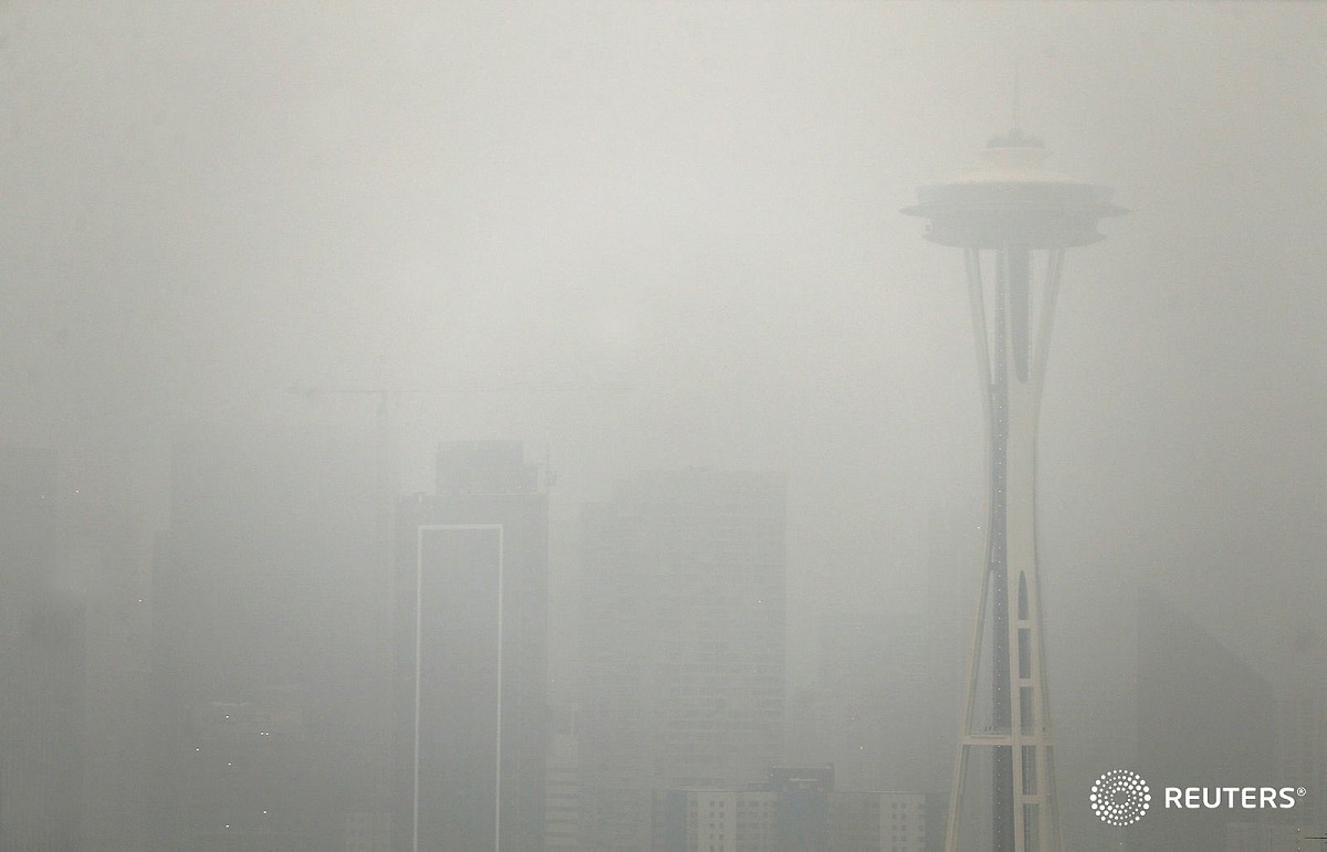
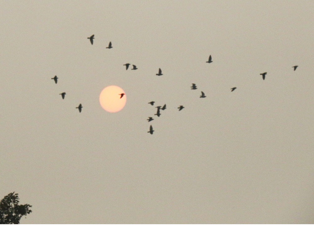
Here’s a flock of pigeons – and yes, I’m looking directly at the sun – at 6.00 pm today.
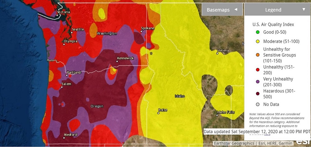
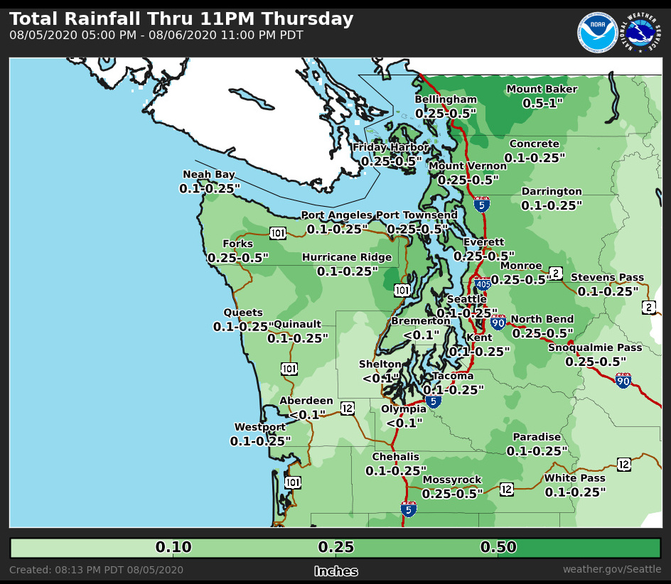
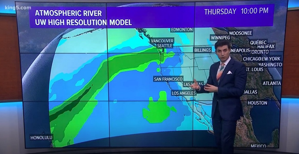
The air quality here in Seattle has improved from ‘Hazardous’ to ‘Unhealthy’. There is a weather system moving in on Friday that should finally bring back blue skies.

Amazing satellite photo tweeted by Puget Sound Clean Air Agency (@pscleanair) on Wed. morning. All of Washington State is covered. I believe the white ridges are clouds and the flat gray lower down must be smoke.

Monday/ the smoke blanket stays

There was no good news in the weather forecast tonight.
A low-pressure system in the Pacific will continue to bring in smoke from the south, and the little bit of rain tonight is not going to clear the the foul air that is blanketing the city, either.
It’s going to be a few more days, at least.

Mr Squirrel, chewing on a little pine cone that had dropped from a Douglas fir in my yard. He didn’t seem to be bothered by the smoky air.

Saturday/ the air is orange – and poison

It’s 1.15 pm here in Seattle, and there is an eerie orange haze outside.
The sun has yet to break through the combination of marine layer fog and thick smoke from the west coast’s man-made fires. (Calling them wildfires seems like a cop-out, as if humans had no part in it).

Don’t go outside, they tell us – it’s hazardous for your health. Large swaths of Oregon have an air quality index reading of 500+ .. off the charts and beyond what is called ‘Hazardous’. [Map from airnow.gov].
Whoa .. hopefully some of this is marine layer fog. Picture from Saturday morning, I believe. [Picture Credit: Reuters/ Karen Ducey]

Tuesday/ the hellscapes of summer

There was a place in the greater Los Angeles area that hit 121°F last week. That’s 49.5 °C. And so many fires— the fires that get worse every summer— in California, in Oregon and in Washington State.

Mostly sunny & smoke haze (87 °F/ 30.5 °C) for the city of Seattle tomorrow.

476 027 acres is 743 sq miles. I asked Google how many acres get scorched by wildfires every year, in Washington State. It seems the average is around 1 million acres (1,500 sq miles). That’s 2% of Washington State (71,000 sq miles).

Wednesday/ Table Mountain’s table cloth

Table Mountain (elevation 3,563 ft/ 1 086 m) in Cape Town, South Africa, has an inch of snow on it.
Snow on the mountain is unusual, but not unheard of (there was snow in 2017).
The cable car up to the top has reopened (with masks required & a limited number of passengers).

A rock hyrax, also called the Cape hyrax, tries to catch a few rays of sun to warm up.  That’s Cape Town and Table Bay in the distance. [Photo Credit: Table Mountain Aerial Cableway Company]

Saturday/ a dry August

We have only had 0.29 in of rain this August (average 0.75 in), and there is no precipitation in the forecast through the end of next week.

A glimpse of the sun from 18th Ave here on Capitol Hill. Monday marks the end of meteorological summer here in the north: June, July & August. (Meteorological seasons that use the exact calendar months make it much easier for meteorologists and climatologists to analyze seasonal statistics, which is crucial information for agriculture, commerce, and many other parts of the economy).

Wednesday/ hurricane Laura

Hurricane season has started, and hurricane Laura is bearing down on the Texas & Louisiana coastline.  The storm had sustained winds of about 140 miles per hour in the Gulf of Mexico, and will dump up to 10 inches of rain onto areas close to the coast.

City and county officials in Texas and Louisiana have issued evacuation orders affecting more than 500,000 residents, particularly those living in low-lying areas. The Covid-19 epidemic is and added complication, and many of these residents simply do not have the means to evacuate.
Laura is expected to make landfall late Wednesday night or early Thursday, most likely in the marshy plains near the Texas-Louisiana state line. [Graphic from the New York Times].

Sunday/ 98 and .01 in of rain

Well, we did get up to 98 °F (almost 37 °C) today.
As the sun was setting tonight, there was a startling burst of thunder from the clouds over the city. (Thunderstorms were not mentioned in the weather bulletins that I had followed).
Just a few drops of rain fell here in the city, though – the kind that gets recorded as 1/ 100th of an inch, I suspect.

The clouds that had moved in, and beautiful fiery colors in the distance:  the view from West Seattle as the sun was setting. [Picture posted by WestSeattleWx@WestSeaWx on Twitter].

Saturday/ the heat is here

The weatherman says we may see temperatures as high as 97 °F (36 °C) here in the city tomorrow. I wish I had a swimming pool.

These pictures are from May, taken by a homeowner in Ottawa, Canada. Police and conservation officials arrived to help, but the moose found her way out of the pool and went on her way.

Wednesday/ it’s still summer

We only got  72 °F (22 °C)  here in the city today, but it looks like Sunday will be warm: 90 °F (32 °C).

Here’s a set of whimsical forest fairytale items that I found next to the sidewalk in a garden here on Capitol Hill. 

Wednesday/ rain on the way

There is rain on the way for Thursday, says the meteorologists.
Yes! I need it to dissolve and disperse the dry moss treatment that the gutter cleaners had left on my roof.

Sunday/ wild blackberries

These wild blackberries (Rubus fruticosus) are by the Amy Yee tennis courts where I played a little social-distance tennis today. The plant is a prickly, scrambling, woody shrub, and is actually considered an invasive species in many areas.

The dry summer weather continues here in the city (79 °F/ 26 °C today).
There were clouds and a chance of drizzle on Saturday morning, but it stayed dry.

The average number of rainfall days in July is 5, and for August it is even lower at 4.8.

Sunday/ a flower, aflame

It’s going to be warm (for Seattle, that is) this week — 87 °F (30.5 °C) on Monday, and slightly cooler on Tuesday.

Whoa .. is it a flameball? Is it a flower? A dahlia, that I found here on 18th Ave.

Tuesday/ graupel

I learned a new word today from our local TV weatherman: graupel.

Graupel is precipitation that forms when tiny, super-cooled water droplets glom onto snowflakes. The soft snowy pellets then fall down to earth.

This must be sleet or fine hail (hard pellets), that fell here in my yard today, and not graupel. Graupel’s consistency is that of opaque white snowy pellets.

Wednesday/ the Volunteer Park Water Tower

It was another beautiful day here in Seattle.
I wanted to get a clear view of Mt Rainier, and the observation deck of the Water Tower here in Volunteer Park on Capitol Hill was a good place to go to get that. And hey, no entry fee: it’s free of charge.

The Water Tower in Volunteer Park was built in 1906 and is 75 ft (23 m) tall.
A Maurits Escher-esque illusion: does this staircase inside the Tower go up, or down? (It goes down).
The observation deck inside allows for 360 degree views. The sun was low on the horizon right by the Space Needle, though, and so I will have to go back in the morning some time, to take a nice Space Needle picture.


Ta-da! The Mountain* is completely out, a cloudless blue sky above it.
*Mt Rainier, a Strato-volcano mountain in the Cascade Range | Elevation 14,411 ft (4,392 m) | Last eruption: 1894.
This is the entrance/ exit facing Prospect St. MCMVI, says the Roman numerals: 1906. The brown signpost on the right says ‘Climbing Prohibited’. So that must mean that rock climbers have tried to scale the uneven outer brick wall with its toeholds and finger holds!

Tuesday/ lots of sunshine

There was sun and blue sky all day here in the Emerald City.
Even so, it was only 47 °F (8° C).

As I walked down to the Capitol Hill Library today, though, bright sunlight would bounce off windows from the buildings nearby and onto me, and I instantly felt the radiated heat on my face.

The Daniel K. Inouye Solar Telescope has produced the highest resolution image of the sun’s surface ever taken. In this picture, taken at 789 nanometers (nm) wavelength, we can see features as small as 30 km (18 mi) in size for the first time ever. The image shows a pattern of turbulent, “boiling” gas that covers the entire sun. The cell-like structures — each about the size of Texas — are the signature of violent motions that transport heat from the inside of the sun to its surface. Hot solar material (plasma) rises in the bright centers of “cells,” cools off and then sinks below the surface in dark lanes in a process known as convection. In these dark lanes we can also see the tiny, bright markers of magnetic fields. Never before seen to this clarity, these bright specks are thought to channel energy up into the outer layers of the solar atmosphere called the corona. These bright spots may be at the core of why the solar corona is more than a million degrees. [Photograph: Highest resolution photo of Sun (NSF) as of January 20, 2020 NSO/AURA/NSF]

Saturday/ pink and blue street cars

The rain let up a little today, but some cold air moved in from the Pacific, pushing temperatures down again into the mid-40s (6° C).

Thank heavens for the rainbow crosswalks, and the blue and pink street cars, I thought, as I walked along Broadway today. They bring some color — to counter the gray skies and sidewalks.

Thursday/ the river in the sky

A break in the rain in January here in Seattle, means you have to jump at it, and go for a walk. We had an even rainier-than-usual start to the year here, with 8.04 in so far at Seatac Airport. The average for Jan. is 5.2 in.

It’s not over yet, for January rain! Another inch or two will get added to the rain totals for some places with an ‘atmospheric river’ moving in. (A little dramatic, that description, no?).  I guess it will help to alert people in flood-prone places to be on the lookout. There is a lot of snow on higher elevations that can melt with the rain and make trouble. [Meteorologist Jordan Steele on King5 TV].

Sunday/ raindrops keep falling on my head

I cut my walkabout in downtown Seattle short today when big raindrops started to come down again.
It was 52 °F/ 11 °C with blue skies when I started out, but grey rain clouds soon swept in from the Pacific.

It was still clear by the time I had walked down to the Capitol Hill train station, with its brand new apartment buildings ..
.. but by 4.20 pm the rain had arrived. This is the view looking towards West Seattle across Elliott Bay, from the top deck at Pike Place market. That’s the MV Kitsap ferry on the left (built in 1980), setting out for Bremerton. The one approaching in the distance is probably coming in from Bainbridge Island. (Ferry traffic was down for the first time in 7 years in 2019, by 3% from 2018. Officials note that the severe winter weather in Feb. 2018, as well as the construction of the new terminal at Colman dock, are probably the main reasons for the decline).

Friday/ checking the snowpacks

Wow .. the snowpack levels in the mountains and higher elevations have improved dramatically. Snoqualmie Pass (at 3,000 ft on Interstate 90) had 6.7 feet/ 2.04 m of snow in 6 days.

There should still be more accumulation to come, though.
April 1 of every year is (on average) when the snowpack depths peak, and the snow starts to melt in spring.

The latest snow telemetry (SNOTEL) report shows values that are now near normal for this time of year.